


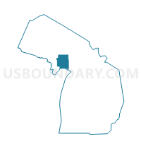
Voting District 0413230000002, Delta County, Michigan
About
Outline

Summary
| Unique Area Identifier | 596331 |
| Name | Voting District 0413230000002 |
| County | Delta County |
| State | Michigan |
| Area (square miles) | 4.16 |
| Land Area (square miles) | 4.16 |
| Water Area (square miles) | 0.00 |
| % of Land Area | 100.00 |
| % of Water Area | 0.00 |
| Latitude of the Internal Point | 45.85381710 |
| Longtitude of the Internal Point | -87.03874840 |
Maps


Graphs
Select a template below for downloading or customizing gragh for Voting District 0413230000002, Delta County, Michigan


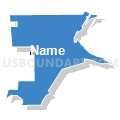


Neighbors
Neighoring Voting District (by Name) Neighboring Voting District on the Map
- Voting District 0, Delta County, MI
- Voting District 0410998000001, Delta County, MI
- Voting District 0412638000001, Delta County, MI
- Voting District 0413230000001, Delta County, MI
- Voting Districts not defined, Delta County, MI
Top 10 Neighboring County Subdivision (by Population) Neighboring County Subdivision on the Map
- Gladstone city, Delta County, MI (4,973)
- Escanaba township, Delta County, MI (3,482)
- Brampton township, Delta County, MI (1,050)
- County subdivisions not defined, Delta County, MI (0)